The slow process towards the warm season is underway as heat builds across the southern part of the nation. There is still plenty of cold air in Canada which attempts to dive into the US. When this cold air dives southward, warmer air is driven northward and a storm is created.
The process explained above will get going on Monday and affect our area Monday night into Tuesday. Before we get there, sunshine will be on the increase this afternoon, in combination of a wind that is not coming off the water, will allow temperatures to be in the 50s. Boston has hit 52 degrees at the time of this write up.
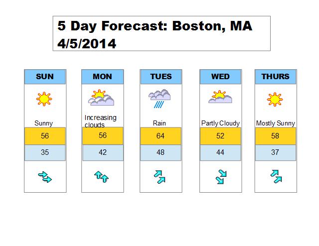
Ample sunshine will be the story on Sunday with a continued west wind so expect 50s for most of the day. Sun will start the day on Monday, but clouds will increase during the afternoon as the system will make it’s approach. This storm will pass to our west, which puts us on the warm side of things. A period of rain is likely Monday night into Tuesday with close to an inch of rain can be expected. It will be quite chilly for the first part of the storm as winds will be coming off the water. As the storm progresses through the area, the wind will shift to a more southwesterly direction which will pump warm air into the region Tuesday afternoon. There may be a slight humid feel as well before the cold frontal passage Tuesday night. Another note, if we can get more sun Tuesday afternoon, temperatures will really climb. Either way 60s can be expected.
Wednesday and Thursday are expected to dry and seasonable.
5 day forecast for the Boston area, click to enlarge.