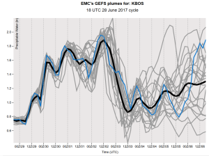
Low precipitable waters are present for the 00z/29 time frame, which is resulting in comfortably dry weather in the Boston area. Dew points are hanging in the 40s currently, which is temporary, and will begin to climb over the next 24-36 hours. Multiple surges of warm/moist air will occur as a Bermuda high establishes itself.
The first surge moves overhead early Thursday morning, mainly bringing a batch of mid-level clouds, but I think we stay dry as low levels remain dry. Dew points will gradually rise into the 50s with an increasing southwest flow.
Once the first frontal boundary pushes north, it will remain to our north, which may keep the second surge from becoming eventful for the Boston area. Additional moisture will advect in from the west, which will cause dew points to climb into the 60s on Friday, along with temperatures in the 80s.
With an approaching pre-frontal trough moving into a warm sector air-mass, will have to watch the threat for showers and thunderstorms later Friday. This axis of lift will hang around through Sunday, which will maintain the risk for thunderstorms as it feeds on the diurnal instability. The cold front finally moves through later Sunday, which will bring drier and less humid air by Monday.


