The roller coaster ride continues as we enter the third week of March.
And no I’m not talking about this roller coaster

Boston’s high temperature today was 37 degrees which occurred at around midnight. Much of the day was spent around 34 degrees which is a good 11 degrees below where we should be for this time of year. That is also 23 degrees colder than yesterday’s high temperature. A rather significant change in temperature in a short period of time. There was also a brisk wind out there today which made temperatures feel even colder than they actually were.
A broad area of high pressure builds into Northern New England while a storm system passes south New England. Mid and high level clouds have made their way into the southern portion of New England and will only reach as a far north as the MA/NH boarder. Light snow should reach the south coast of New England overnight and into early Monday morning. Little to no snow accumulation expected for the areas that receive snow. A very cold night is expected where clouds don’t reach, which is much of Central and Northern New England. Conditions here will be excellent for radiational cooling with many Northern New England areas dropping below zero.
Monday will be just as cold for all, but sunshine(clouds to start for southern areas) and less wind will make it feel a little less harsh during the afternoon. Monday night is expected to be very cold for all. The mid March sun quickly goes to work Tuesday morning with a rapid rebound expected as high temperatures are expected to be a bit warmer than Monday.
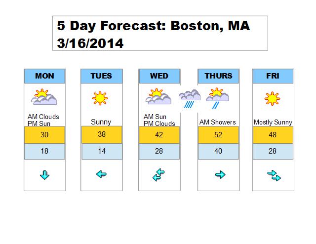
Wednesday starts out with mostly sunny skies as temperatures rise into the 30s north 40s south. Clouds increase during the afternoon in response to a fast moving system. Temperatures in Southern New England will be warm enough for rain showers Wednesday evening and overnight. A mix of rain and snow showers for Central New England and Northern New England. Precip type dependent upon elevation. Clouds and light precipitation may linger into Thursday but drying and clearing is expected throughout the day. Most areas should receive sunshine during the afternoon so I expect 50s for Southern New England with upper 30s and 40s for Central and Northern New England.
Friday is expected to be a dry day with temperatures near average for much of Southern New England but below average in Northern New England due to deep snow pack. Another fast moving system speeds through the region Saturday with another mix of light rain and snow possible.
Below is a quick look at the next 5 days for the Boston area. Click to enlarge.