An Emerging Bermuda Ridge

Capture


Low precipitable waters are present for the 00z/29 time frame, which is resulting in comfortably dry weather in the Boston area. Dew points are hanging in the 40s currently, which is temporary, and will begin to climb over the next 24-36 hours. Multiple surges of warm/moist air will occur as a Bermuda high establishes itself.


The first surge moves overhead early Thursday morning, mainly bringing a batch of mid-level clouds, but I think we stay dry as low levels remain dry. Dew points will gradually rise into the 50s with an increasing southwest flow.


Once the first frontal boundary pushes north, it will remain to our north, which may keep the second surge from becoming eventful for the Boston area. Additional moisture will advect in from the west, which will cause dew points to climb into the 60s on Friday, along with temperatures in the 80s.

With an approaching pre-frontal trough moving into a warm sector air-mass, will have to watch the threat for showers and thunderstorms later Friday. This axis of lift will hang around through Sunday, which will maintain the risk for thunderstorms as it feeds on the diurnal instability. The cold front finally moves through later Sunday, which will bring drier and less humid air by Monday.


Posted in Forecasts | Leave a comment

May 2017 Review And Extended Outlook

May 2017 Review

1

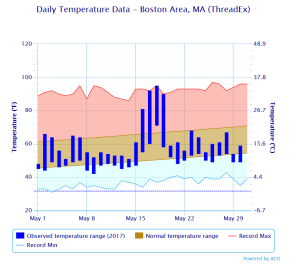
If you take a look at the graph above, you will see blue rectangles varying in size for each day of May, besides today. Those rectangles represent how the temperature ranged in a 24 hour period in Boston, with the bottom representing the lowest recorded temperature, and the top of the rectangle indicating the maximum temperature.

If one were to take a quick glance and give a monthly assessment on temperature, I would say it was a chilly month, featuring many cloudy days and/or days that were dominated by onshore flow/sea breeze. Days that were sunny and had a modest offshore flow nearly broke high temperature records.

2

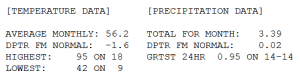
If you put all those numbers together, the month will end up 1.6 degrees cooler than the 30 year average, despite a high temperature of 95 degrees on the 18th. Rainfall should remain close to average despite what may try to survive later on, more on that below.


Next 12 Hours

3

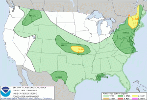
Going back to the temperature graph real quick, it’s easy to notice the rather consistent temperature pattern as of late, which lacks significant diurnal range, and falls short of average. This temperature pattern suggests a marine layer has been in place for quite some time, which is consistent with observed wind directions ranging from east to northeast. Now taking a look at the SPC day 1 outlook for severe weather, there is a sharp gradient in threat located right along the western extent on the marine layer, just to the west of Boston. Convection has already initiated in western NY where sufficient diurnal heating and mid-level drying are occurring. Given the lack of a front, these storms will remain in clusters as they move east. Once the storms encounter the marine layer, they will weaken quickly, providing little to no impact to the Boston area.


Looking Beyond

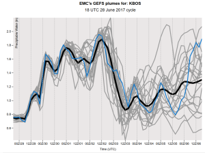
Referring back to my discussion on the temperature pattern, the warmest days occurred with ample sunshine and offshore wind flow. We will be very close to the pattern Thursday through Sunday, although recent rainfall and cool air aloft will allow for daily cloud build up. The two graphics above and below describe trends in moisture and wind profiles over time. On the left is a range of model solutions for moisture quantity and on the right is a single solution for wind direction and speed. Time, which is on the horizontal axis is in Zulu time, where 12z is 7AM and 00z is 7PM.

Moisture returns gradually into next week, with unknown extent denoted by large ensemble spread. The wind flow returns to an onshore direction Monday and Tuesday, bringing a renewed period of persistent cloudiness and cool temperatures, along with the threat for rainfall. Needless to say, enjoy Thursday through Sunday.

Posted in Forecasts | Leave a comment

Here Comes The Sun

Today could have qualified as an early summer day with the warm temperatures and slight muggy feeling. If we had more sun today then we would have reached the 70 degree mark.

The storm that has been impacting us is moving out and dragging along a cold front with it. This front will pass by this evening, taking the humidity with it. A secondary cold front will pass through overnight, dropping temperatures into the 40s. A brisk northwest flow and cooler air aloft will result in a cooler day tomorrow, however the sun will be out in full force. We warm a couple degrees on Thursday to near 60 with a southwest flow and plenty of sunshine.

A front stalls south of our area on Friday which will produce clouds and a chance for some showers. A weak fast moving system moves through the area on Saturday spreading more clouds and showers.

All of that moves out for Sunday with a good deal of sunshine. Light winds may allow for a sea breeze to develop in the afternoon.

Below is a 5 day forecast for Boston, click to enlarge.

4 8

Posted in Forecasts | Leave a comment

Marching Forward

The slow process towards the warm season is underway as heat builds across the southern part of the nation. There is still plenty of cold air in Canada which attempts to dive into the US. When this cold air dives southward, warmer air is driven northward and a storm is created.

The process explained above will get going on Monday and affect our area Monday night into Tuesday. Before we get there, sunshine will be on the increase this afternoon, in combination of a wind that is not coming off the water, will allow temperatures to be in the 50s. Boston has hit 52 degrees at the time of this write up.

Ample sunshine will be the story on Sunday with a continued west wind so expect 50s for most of the day. Sun will start the day on Monday, but clouds will increase during the afternoon as the system will make it’s approach. This storm will pass to our west, which puts us on the warm side of things. A period of rain is likely Monday night into Tuesday with close to an inch of rain can be expected. It will be quite chilly for the first part of the storm as winds will be coming off the water. As the storm progresses through the area, the wind will shift to a more southwesterly direction which will pump warm air into the region Tuesday afternoon. There may be a slight humid feel as well before the cold frontal passage Tuesday night. Another note, if we can get more sun Tuesday afternoon, temperatures will really climb. Either way 60s can be expected.

Wednesday and Thursday are expected to dry and seasonable.

5 day forecast for the Boston area, click to enlarge.

4 5

Posted in Forecasts | Leave a comment

Who Likes Roller coasters?

The roller coaster ride continues as we enter the third week of March.

And no I’m not talking about this roller coaster

roller-coaster-8

Boston’s high temperature today was 37 degrees which occurred at around midnight. Much of the day was spent around 34 degrees which is a good 11 degrees below where we should be for this time of year. That is also 23 degrees colder than yesterday’s high temperature. A rather significant change in temperature in a short period of time. There was also a brisk wind out there today which made temperatures feel even colder than they actually were.

A broad area of high pressure builds into Northern New England while a storm system passes south New England. Mid and high level clouds have made their way into the southern portion of New England and will only reach as a far north as the MA/NH boarder. Light snow should reach the south coast of New England overnight and into early Monday morning. Little to no snow accumulation expected for the areas that receive snow. A very cold night is expected where clouds don’t reach, which is much of Central and Northern New England. Conditions here will be excellent for radiational cooling with many Northern New England areas dropping below zero.

Monday will be just as cold for all, but sunshine(clouds to start for southern areas) and less wind will make it feel a little less harsh during the afternoon. Monday night is expected to be very cold for all. The mid March sun quickly goes to work Tuesday morning with a rapid rebound expected as high temperatures are expected to be a bit warmer than Monday.

Wednesday starts out with mostly sunny skies as temperatures rise into the 30s north 40s south. Clouds increase during the afternoon in response to a fast moving system. Temperatures in Southern New England will be warm enough for rain showers Wednesday evening and overnight. A mix of rain and snow showers for Central New England and Northern New England. Precip type dependent upon elevation. Clouds and light precipitation may linger into Thursday but drying and clearing is expected throughout the day. Most areas should receive sunshine during the afternoon so I expect 50s for Southern New England with upper 30s and 40s for Central and Northern New England.

Friday is expected to be a dry day with temperatures near average for much of Southern New England but below average in Northern New England due to deep snow pack. Another fast moving system speeds through the region Saturday with another mix of light rain and snow possible.

Below is a quick look at the next 5 days for the Boston area. Click to enlarge.

3 16


Posted in Forecasts | Leave a comment

An Active March Week

This week will feature quite the roller ride with temperatures and a coastal storm.

Boston has managed to climb to the middle 40s on this Monday afternoon despite the abundant clouds in place. These clouds won’t be around for Tuesday so I expect a warmer day with temperatures in the middle 50s. A similar day to this past Saturday.

Then we turn our heads to an approaching storm on Wednesday. A large surge of warm air and moisture ahead of it will result in a swath of rain Wednesday afternoon and into the night. Once the area of low pressure is to our east, and more northerly flow will develop and temperatures will plummet. This puts us at early Thursday morning where it will be cold enough for snow. However it is difficult to tell how much precipitation will be around at this time. A quick couple of inches is possible, but not certain on that.

Thursday will be a cold day as a piece of arctic air will be in place and I don’t think we will be seeing the sun at all. Thursday afternoon is dry. This arctic air lifts out for Friday as temperatures climb closer to average. Mild weather returns for Saturday with a developing southwest flow.

3 10

Posted in Forecasts | Leave a comment

Snow Escapes While Cold Penetrates

A massive upper-level low continues to wobble around southeast Canada which will help support below average temperatures for the majority of the next 5 days. Perhaps by Friday temperatures will climb closer to normal values for early March.

Boston did manage to reach 40 degrees today but it was brief as most of today was spent in the 30s. An easterly wind direction in place now will switch over to a more northerly wind direction so I expect temperatures to be near 20 by Monday morning.  A round of light snow is possible overnight with a coating possible.

850mb temperatures for Monday will be around -15C, combined with a northerly flow and high clouds, will prevent temperatures from rising much from the Monday morning low. Wind chills will be in the teens. A cold night is expected Monday night.

High pressure builds in for Tuesday, which will promote plenty of sunshine and less wind. However 850mb temps still running around -15C so high temperature will be in the 20s. Wednesday is still cold with more clouds around and a light northerly flow.

I am watching an ocean storm towards the end of the week, but for now that looks to stay out at sea. Either way cold air begins to retreat after midweek.

Posted in Forecasts | Leave a comment

Cold Persists, Snow Chance Increase

The main purpose for this blog update is to mention the snow possibility for Monday as it has moved into the 5 day forecast.

A series of short wave troughs will move through the area during the next few days which will help keep the cold air well intrenched. One of these short waves affects the area tomorrow, however it will be moisture starved. A few snow showers can be expected in the afternoon. Surface high pressure builds in behind the shortwave for Friday, so dry and cold weather can be expected.

The next short wave will affect the area Sunday night into Monday. This is the one to watch as this one will have Gulf of Mexico moisture to work with.

A front will pass the region from north to south on Sunday and will stall to our south. The question is where does it stall as that is where an area of low pressure will track. Since the frontal boundary will be to our south, we will be in the cold air which will support snow. I hope to update as soon as possible once I have a better idea.

Posted in Forecasts | Leave a comment

Winter Chill

A cold day was felt again today as Boston failed to reach 30. Winds were still with us so the thought of spring is a distant memory now. Temperatures fall into the teens overnight so bundle up tomorrow morning if you are going out.

A few snow showers can be expected tomorrow as a weak disturbance passes to our south and aids in the development of a big ocean storm. It will not affect us with snow but it will help tug down colder air. Before that happens, temperatures will reach close to where they were today. Wednesday night will be cold with lows getting down to the lower teens. A southerly flow on Thursday will help temperatures rebound to the upper 20s despite a cold start and a good deal of clouds. Cold and dry weather persists through the weekend.

Detailed forecast for the Boston area…

Tonight: Mainly clear. Low 17. Wind W 5-10 MPH.

Wednesday: Cloudy with a chance for a few snow showers. High 28. Wind W 10-15 MPH.

Wednesday Night: Mainly clear and cold. Low 12. Wind W 0-5 MPH.

Thursday: Mostly cloudy. High 28. Wind S 10-20 MPH.

Friday: Sunny and Cold. High 23.

Saturday: Mostly cloudy. High 30.

Sunday: Mostly Cloudy. High 32.


Posted in Forecasts | Leave a comment

Cold Spell!

Hello readers!

Over a year has passed since my last post on here, but I found new motivation to start up again! I have been studying meteorology in college for nearly 2 years now, so my forecasts will now have more thought and logic put into them. Participation in a forecasting challenge has substantially increased my weather forecasting skill.

Now for the weather…This weekend has been a preview of early spring as Boston hit 50 degrees both yesterday and today. The average high temperature for today in Boston is 40 degrees, so definitely a warm weekend when comparing the actual high temperature with the average high temperature.

Mother Nature is far from ready for spring. When taking a look at the large scale pattern, A massive cold pool of air aloft will drop down from the North Pole and into Southeast Canada. This massive cold pool of air will sit and wobble throughout next week, but does not enter our neck of the woods. Since this cold pool is massive, it will have a significant impact on our weather for the week ahead. Colder than average temperatures are likely while storm chances up in the air.

This section will focus on the weather in the Boston area for the next week. Colder air is moving into our area at the surface and especially aloft. Boston is currently 44 degrees, and is expected to be around freezing by morning. The temperature will hold near freezing and will begin to drop in the afternoon. Active winds and limited sunshine will make Monday feel like a mid-winter day. Teens are expected Monday night.

As mentioned above, the rest of the week looks cold but a chance for snow exists for Wednesday and the weekend. Both chances of snow depend of the storm tracks and how much precipitation gets thrown into the Boston area.

Detailed forecast for the Boston area…

Tonight: Cloudy. A slight chance for a snow shower after midnight. Low 28. Wind W 5-15 MPH.

Monday: Mostly sunny skies to start the day, then becoming mostly cloudy by noon. Much colder with a high of 33. Wind W 10-20 MPH with gusts up to 30 MPH.

Monday Night: Decreasing clouds. Cold. Low 16. Wind W 5-15 MPH.

Tuesday: Mostly cloudy. High 28. Wind W 10-15 MPH.

Wednesday: Cloudy with a chance of snow. High 28.

Thursday: Partly cloudy. High 28.

Friday: Partly cloudy. Cold. High 25.


Posted in Forecasts | 1 Comment